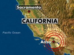
4.7 magnitude quake shakes Los Angeles: residents told to prep for 2 weeks and be prepared for disasters
 March 12, 2013 – LOS ANGELES, CA – An earthquake with a magnitude of 4.7 was reported in Anza, California. The quake was the first of several that popped up at the same time Monday on the U.S. Geological Survey website. It was originally reported as a 5.2 magnitude quake but was then downgraded.
The epicenter for the 9:56 a.m. quake was 12 miles east of Anza and 16 miles southwest of Palm Desert. Near the epicenter, Palms Springs police Sgt. Harvey Reed told the Associated Press his department received no reports of damage or injuries. There were no other immediate reports of damage in the region.
It happened along the San Jacinto fault between the San Andreas and the Elsinore faults. This is a fault famous for big earthquakes according to retired geology professor Pat Abbott, Ph.D. “There’s always that slight chance – slight chance now – that this could be the foreshock of something larger. Probably not.
Usually this is just an event all by itself,” Abbot said. “It doesn’t hurt to keep it in mind, in the next 72 hours in particular,” he said. “If a larger one is going to occur it would probably be during that three-day period.”
Residents were urged to prepare for a number of disaster scenarios, including how to cope for being at least “two weeks on your own. The message for a lot of us needs to be, ‘Be ready for anything’,” said Battalion Chief Larry Collins. “The message used to be 72 hours, but we’ve seen in disasters like [Hurricane] Katrina, even [Hurricane] Sandy recently, that, really, if it’s wiped out your infrastructure, and your electricity grid and your communications, it will be very likely be more than three days before you start getting food, water and other supplies coming in from outside.” –CBS NBC
 New Madrid quake: A small earthquake measuring 2.7 magnitude hit near Benton in southern Illinois this morning but appears to have done little, if any, damage in the rural area. The quake occurred around 5 a.m. about 11 miles east of where Interstate 57 passes through Benton, the seat of Franklin County, according to the U.S. Geological Survey. The closest town is Macedonia, population 50.
The Franklin County sheriff’s office said it had gotten no reports of injuries or damages. The quake hit to the north and west of what is called the New Madrid seismic zone. Strong earthquakes from the New Madrid fault and other faults in what’s known as the Illinois Basin-Ozark Dome area have hit southern Illinois and nearby parts of Missouri, Arkansas, Indiana and Kentucky over the years, including a series of devastating quakes in 1811 and 1812.
The largest earthquake in the area in memory was in 1968 and registered a 5.4 magnitude, what the geological survey calls a moderately damaging quake. The last strong earthquake to hit southern Illinois was in April 2008, when a 5.2 magnitude quake struck near West Salem, affecting areas including Mount Carmel, about 80 miles east of Benton. –Chicago Tribune
Seismic watch: The planet has now entered a window of elevated risks for a major earthquake to strike somewhere on the planet from now, through March 23, 2013. People in seismically high-risk regions should remain alert and prepared for the potential occurrence or occurrences of seismic events and their associated hazards. –The Extinction Protocol
 March 12, 2013 – LOS ANGELES, CA – An earthquake with a magnitude of 4.7 was reported in Anza, California. The quake was the first of several that popped up at the same time Monday on the U.S. Geological Survey website. It was originally reported as a 5.2 magnitude quake but was then downgraded.