In the few years I've been watching these radar replays, I've never seen anything so powerful as the beams coming into and/or out of the Roanoke station. The pulses apparently shut the station down. Is this all weather control? Or is this possibly space related, as in trying to affect things higher in the atmosphere?
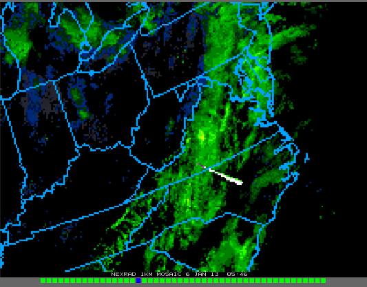
-LAST FRAME PIC
The Roanoke NEXRAD Station KFCX was knocked off the air some time after 5:40 UTC 1/6/13 by 64 electron beams launched over 24hrs by 31 different attacking radar stations. There are no reports of death, injuries or when the radar may be operative.
Last known Beam pic from that station is at bottom.
The pic and list below show the beam trajectories, originating points and facilities, where known, as tracked back from target, line of sight, over the horizon, exact heading to another radar facility. 28 of 31 attackers are identified with 95% certainty.
64 Individual frame pics were acquired from College of du Page
( http://climate.cod.edu/flanis/satellite/reg/index.php?type=usa-rad-48 ) 48 or 200 frames loops of individual station radar. Globe map and features from Google Earth
( http://www.google.com/earth/download-earth.html )
Dutch Sinse says this ‘Vortex’ event at Roanoke caused the concurrent EQ off the W. Canada coast: direct VIDEO link with unique perspective
http://www.youtube.com/watch?v=pO3nhRNpJH0&feature=em-uploademail
similar to the Vortex in Mexico: redirect GRAPHIC link
http://www.youtube.com/redirect?q=http%3A%2F%2Fsincedutch.wordpress.com%2F2012%2F10%2F28%2F10282012-mexico-canada-spiral-vortex-shaped-radar-return%2F&session_token=dL3H4UU34ejo-qclcqCuYrrw4dx8MTM1NzU4Mzg0M0AxMzU3NDk3NDQz
What do you think about all of this?

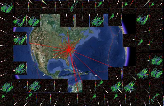
List of attacking radar sites with name, location, orientation, distance and numbered from 1 to 31. Starting clockwise from 12 position (attacker number 31) the first trajectory line to the right (clockwise) is number 1.
(1) KING CITY ON 480 MI 30 degrees
(2) STATE COLLEGE PA 299 MI NNE
(3) KBGM BINGHAMTON NY 421 MI NNE
(4) KGYX PORTLAND ME 712 MI 225 degrees
(5) KDOX DOVER AFB NJ 294 MI ENE
(6) NASA WALLOPS VA 275 MI ENE
(7) NOAA WALLOPS VA 262 MI ENE
(8) SUPERDARN BLACKSTONE VA 129 MI E
(9) UNKNOWN ATTACKER
(10) TTA ASCENSION ISL 5,257 MI 295 degrees
(11) HAARP BRAZIL 3,567 MI 46 degrees
(12) UNKNOWN ATTACKER
(13) GUANTANAMO BAY CUBA 1,218 MI S
(14) CARIBE COLUMBIA AIRPORT 1,881 MI S
(15) SUPERDARN ANTARCTIC HALEY 8,096 MI S
(16) KAMX MIAMI FL 808 MI SSW
(17) KVAX MOODY AFB GA 451 MI 20 degrees
(18) KTLH TALLAHASSEE FL 514 MI 28 degrees
(19) KEVX EGLIN AFB FL 550 MI SSW
(20) KMOB MOBILE AL 627 MI SW
(21) KLCH LK CHARLES LA 885 MI 61 degrees
(22) KGWX COLUMBUS AFB MS 500 MI SW
(23) KSHV SHREVEPORT LA 833 MI WSW
(24) KSRX FT SMITH AR 796 MI W
(25) KVBX VANDENBERG AFB CA 2,239 MI WNW
(26) KILX LINCOLN IL 537 MI WNW
(27) KTFX GREAT FALLS MT 1,726 MI 122 degrees
(28) KIWX N WEBSTER IN 416 MI NW
(29) DETROIT MICHIGAN 426 MI NNW
(30) KCLE CLEVELAND OH 314 MI NNW
(31) SUPERDARN KAPUSKASING ON 856 MI N
We are going to make a big mistake if we are not careful.