A series of volcanoes have erupted. What's interesting here is that they are all over the place, not just in one region. The increased earthquake activity is a precursor to the volcanoes. Especially watch for the volcanoes on America's west coast, from Washington down through Southern California. It's coming.
Upswing in earthquakes in the Long Valley caldera region of California
 November 29, 2012 – CALIFORNIA – An upswing in California earthquakes has some people questioning the health of the fault lines. Long Valley Caldera to Mammoth Mountain are swarming at the same time. Earthquakes are the normal in California, however within the last week an upswing in activity has been noted. The Long Valley Caldera is showing signs that magma is indeed moving down there. The Long Valley Caldera is something that is dismissed due to the Yellowstone Super Volcano. There is evidence in the past that the Long Valley Caldera is more dangerous than Yellowstone, and just a stone’s throw away from the populated regions of Southern California. The caldera is just north of Ridgecrest off of Highway 395 and activity has been spiking within the last week. “We don’t think much is going on there, but it is being monitored,” said the USGS. “We have teams in the area and have just recently finished a study on the area.” So while no one can predict what will happen, just as Yellowstone, the Long Valley Caldera is considered a super volcano that can go off at anytime. “We’ve notice an increase in 2s and 3s across California as well, with poppers across Southern California,” said TheWeatherSpace.com Senior Meteorologist Kevin Martin. “This usually means we are going to have the stress released soon in the area. What is also interesting is Long Valley and Mammoth Mountain activity is happening at the same time. This is real interesting.” According to Jim Berkland, a retired geologist, Full Moons usually generate large earthquakes due to the tidal forces. There is a lunar eclipse tonight so the moon can’t get any fuller. –The Weather Space
Indonesia’s Mount Lokon volcano erupts, spewing ash 3.5 km high
 November 29, 2012 – INDONESIA – Mount Lokon volcano in North Sulawesi erupted on Wednesday, spewing ash up to 3.5 kilometers to the sky, without report of fatality and evacuation, officials said. Head of National Volcanology Surono said that the eruption took place at 10:05 local time (0205 GMT). He said that the agency had asked people living near the crater to be alert. “We issued warning to the people living 2.5 kilometers from the crater,” Surono told Xinhua by phone. Spokesman of National Disaster Management and Mitigation Agency (BNPB) Sutopo Purwo Nugroho confirmed that there was no evacuation after the eruption. “There is still no need for evacuation,” he told Xinhua by phone. Indonesia, an archipelago country, is home to 129 active volcanoes. –Xinhua
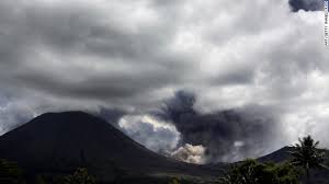
Kamchatka’s Plosky Tolbachik volcano erupts for first time in 36 years
Posted by The Extinction Protocol
 November 29, 2012 – KAMCHATKA, Russia – The 3,085-meter Plosky Tolbachik volcano in Russia’s Far Eastern Kamchatka Peninsula is erupting for the first time in 36 years, according to reports of KVERT, the he volcano monitoring body for Kamchatka. The volcano is located on the peninsula’s eastern coast, 343 km from the region’s capital of Petropavlovsk-Kamchatsky. A bulletin released Tuesday by the Kamchatka Volcanic Eruption Response Team (KVERT), as cited by The Voice of Russia, described a significant explosive eruption with the potential for ash explosions up to 10 km. The eruption at Plosky Tolbachik was given code orange (number three on the four-tiered USGS Volcano Alert Level), meaning it “poses limited hazards.” Scientists say the volcano is obscured by clouds at now, but lava intrusions towards the volcano’s summit caldera are also probable. An ash fall was reported in the nearby village of Krasny Yar. The eruption will be closely monitored for its impact on air travel over the eastern Siberian peninsula. The Plosky Tolbachik volcano erupted only 10 times since records began in 1740. –Novinite
EMO observes intense volcanic activity on Pagan

November 29, 2012 – MARIANA ISLANDS – An intense volcanic activity was monitored by the CNMI Emergency Management Office and captured through satellite images from Nov. 24, 2012, to the present. The volcano has been emitting steam and gas since Friday, Nov. 24, 2012. The vog shows that it’s heading south from Pagan volcano. A gas plume from Pagan has been observed in MODIS satellite images. Minor steam and gas plumes from Pagan have been seen as well. It is possible that the plume could be followed by an ash emission; the presence of a gas plume does not necessarily indicate that eruptive activity will occur soon. Pagan is not monitored with ground-based geophysical instrumentation and the only source of information is satellite observation and occasional reports from observers who visit the island. Also an intense earthquake was recorded at the EMO and National Earthquake Information Center yesterday at 5:34pm Saipan time. The preliminary magnitude is 5.3 on the Richter scale. It was centered some 45 km (27 miles) south of Pagan, Northern Mariana Islands and 276 km (171 miles) north of Saipan, Northern Mariana Islands. Base on all available data no tsunami is expected and there is no tsunami threat for the Marianas. –Saipan Tribune
Residents on alert, as Santiaguito volcano blows its top in Guatemala

November 29, 2012 – GUATAMALA - Guatemala on alert as the Santiaguito volcano (Santa María) dumps plumes of smoke and ash over nearby communities, coating cars and houses in grey dust. –Yahoo News
 Strong eruption: The Santiaguito volcano, in western Guatemala, erupted today with “very strong,” with the release of smoke and ash at high altitudes, so the agency has recommended Meteorology restrict air traffic in the area. So far there is no need for an evacuation of the villages closest to the volcano, which is located about 227 kilometers from Guatemala City. The director of the National Institute of Seismology, Volcanology, Meteorology and Hydrology (Insivumeh), Eddy Sanchez, reported that the activity of the volcano at 2,550 meters, and located in the department of Quetzaltenango, started at about 5.30 local time (11.30 GMT ). Sanchez added that the sand and volcanic ash is dispersed within at least a 4 kilometers radius of the volcano. “There is a crater collapse, pyroclastic flows, and notice has already been given to Civil Aviation to restrict air operations in that region,” said the director of the local radio Insivumeh. He also reported they warned the National Coordinator for Disaster Reduction (Conrad) to take the necessary precautions. Sanchez said the eruption of Santiaguito will last for several hours and urged people to stock up surrounding drinking water because the sand and volcanic ash can contaminate streams that may be harmful to health. The sand and ash has fallen in populations of the departments of Quetzaltenango and Retalhuleu, where they can be affected coffee plantations, according to Sanchez. The volunteer fire departments of these two departments have declared orange alert or prevention, while experts Conrad Insivumeh and keep a constant eye on the evolution of the eruption. -EFE (translated)